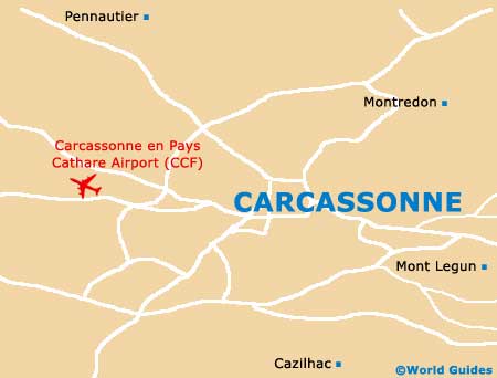
Carcassonne Airport (CCF)
Town Orientation and Maps
(Carcassonne, France)
The town of Carcassonne has long been one of the most popular parts of Languedoc. Located in the south of France, close to the Spanish border, Carcassonne is easy to reach, being a major stop on the Toulouse to Montpellier train line. Also, on the south-western side of town, Carcassonne en Pays Cathare Airport (CCF) is responsible for large numbers of visitors, which regularly fly into the region.
Carcassonne en Pays Cathare Airport (CCF) Maps: Important Town Districts
Carcassonne is actually divided into two main areas as a result of historic wars and disputes. These regions are known as the Cité and the Ville Basse. The main train station, the Gare SCNF, is located in the Ville Basse area of Carcassonne, on the northern side of the scenic Canal du Midi. A further station, the Gare Routière, can be found along the Boulevard de Varsovie, to the north-west.
A scenic trail edges much of the canal and is known as the 'Promenade du Canal'. The town's tourism bureau is situated along the Boulevard Camille-Pelletan, next to the Gambette square and close to the main thoroughfare from Montpellier, which crosses the River Aude.
The Cité area of Carcassonne is home to the best selection of restaurants and traditional French bistros, although they can be a little pricey at times. A number of cheaper dining venues can be found in the Ville Basse area, catering to the thriving tourism trade.
France Map

Carcassonne Map